Lama et al.
and development (Strahler 1964, Kumar et al. , 2012,
mostly pre-Cambrian metamorphic and igneous
Panhalkar et al. , 2012, Yasmin et al. , 2013). Evaluation
rocks. The main rock formations of the study area
ofthemorphometricparametersrequirespreparation
are metamorphosed conglomerates, phyllites and
of drainage map, ordering of various streams,
quartzitesoftheShillongseries(TomarandSatapathy
measurement of the catchment area and perimeter,
2000. The watershed being a part of the Khasi hills
channel length, drainage density and a host of
has an undulating topography comprising of rolling
other parameters which help in understanding the
hills with steep slopes interspersed with valleys and
nature of the drainage basins (Sridhar et al. , 2012).
plateaus.
Geographical Information System (GIS) techniques
provideapowerfulenvironmentandtoolforanalysis,
manipulation and extraction of spatial information
for better understanding. It has been used to assess
various terrain and morphometric parameters of
drainage basins and watersheds (Chopra et al. , 2005,
Kar et al. , 2009, Sharma et al. , 2010, Sridhar et al. , 2012,
Wandre and Rank 2013, Aher et al. , 2014). Narendra
and Nageswara Rao (2006) carried out morphometric
analysis of Meghadrigedda watershed, Andhra
Pradesh, using GIS and Resourcesat-I data, while,
Vincy et al. , (2012) characterized the morphometric
parameters of two sub-watersheds of Meenachil
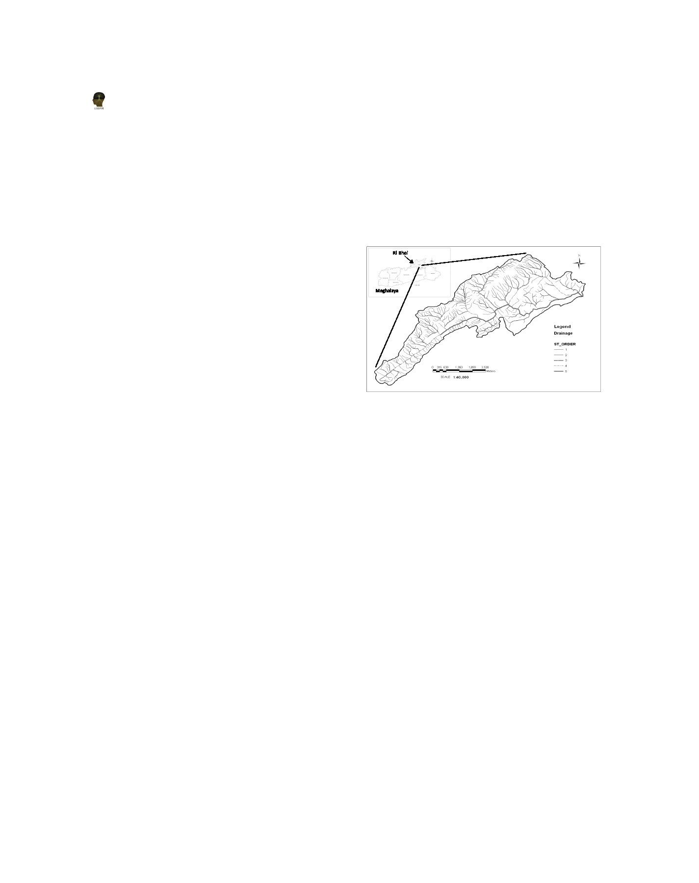
Figure 1. Location and drainage map of Um Shipra watershed
River in the western ghats of Kerala using GIS tools.
showing streams of different orders
In the present study, morphometric analysis of the
Soil erosion is an inherent problem because of steep
Um Shipra watershed located in Ri-Bhoi district of
hill slopes and high intensity of rainfall. The erosion
Meghalaya state in the north eastern part of India
has been further aggravated due to the prevalence
using GIS has been carried out with an objective to
of Jhum (Slash and burn agriculture) and Bun
study the drainage characteristics of the watershed.
cultivation (Raised bed method in which the beds
Materials and Methods
are made along the slopes) on the hill slopes. Though
the watershed receives plenty of rainfall during the
Study Area
monsoon season (more than 2000 mm), due to steep
slopes much of it is lost as surface runoff and only a
The Um Shipra watershed lies between 25° 40′ 14″ to
meager amount infiltrates into the ground. Streams
25° 44′ 10″ N latitudes and 91° 54′ 12″ to 92° 0′ 19″ E
are the major source of drinking water for the people
longitudes in Ri-Bhoi district, Meghalaya (Figure 1)
living in the nearby villages, as well as, for irrigation
and has a total area of 23.85 km 2 . The watershed is
and livestock uses.
characterized by humid, subtropical climate with an
annual average rainfall of 2416 mm, 80% of which is
Methodology
receivedduringthemonthsofMaytoOctober(Tomar
and Satapathy 2000. The mean monthly maximum
Thewatershedboundaryandtheassociateddrainage
and minimum temperatures normally range from
network from the Survey of India toposheets of
20.9 to 27.4°C and 6.7 to 18°C, respectively.
1:25,000 scale was digitized using the ArcGIS
software (Ver. 8.3) and the attributes were assigned
Geologically, the watershed is a part of the Shillong
to create a digital database. Using the hierarchical
plateau, which tectonically falls in the Central
ranking method (Strahler 1964) the stream orders
Assam Range. It is an old land surface made up of
were assigned and the digital database was updated
30